
The following are some examples of the tools and resources in the AKN that the general public might use to answer some common questions:
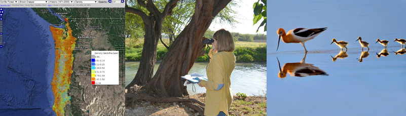
I am just your average bird lover interested in seeing what birds occur where I live, when they usually occur there, and in what months they are in the highest abundance.
[showhide type=”post1″ more_text=”See what tools and resources might help you do this…” less_text=”Collapse…”]
You might like the following tools:
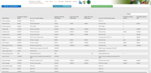
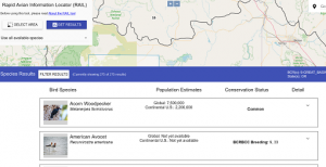 The RAIL Tool allows the user to query a specific geographic location and return a list of birds that are known to occur in that area based on the underlying data in the AKN, along with a wealth of information about those birds including their conservation status and population size at various scales. The tool imports information from the Partners in Flight (PIF) Avian Conservation Assessment Database (ACAD) and the PIF Population Estimates Database, and also incorporates other supplemental information (e.g. conservation status on multiple scales, clutch size, bird weight, size and diet, primary habitat, photos and range maps) that might be helpful for permitting and making conservation and management decisions for birds.
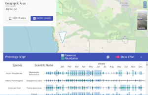
AKN Phenology Tool – The Phenology tool allows the user to view abundance and relative probability of presence summaries throughout the year for birds in a particular region or project area. For a short web tutorial on this tool, please visit the Phenology Tool video tutorial.
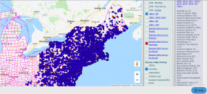
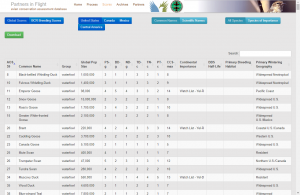
AKN Observations Map – The Observations Map allows the user to visualize, query, and investigate data at surveyed locations by species, survey location or area of interest. It also allows users to view individual datasets separately, and download reports of results. For a short web tutorial on this tool, please visit the Observations Map Tool video tutorial.
[/showhide]
I am interested in seeing the best available information for estimated population size on a variety of scales for the birds in a certain area of the U.S. or Canada.
[showhide type=”post2″ more_text=”See what tools and resources might help you do this…” less_text=”Collapse…”]
Partner’s in Flight (PIF) Landbird Population Estimates Database – This database aims to: (1) provide users access to the estimates of landbird populations published in the North American Landbird Conservation Plan (Rich et al. 2004), which were based mainly on Breeding Bird Survey data from the 1990s: (2) allow users to view and download estimates for landbird populations at a variety of geographic scales, and (3) provide transparent access to the methodologies, assumptions, data sources, and species-specific correction factors used by Partners in Flight to create these estimates.
The RAIL Tool allows the user to query a specific geographic location and return a list of birds that are known to occur in that area based on the underlying data in the AKN, along with a wealth of information about those birds including their conservation status and population size at various scales. The tool imports information from the Partners in Flight (PIF) Avian Conservation Assessment Database (ACAD) and the PIF Population Estimates Database, and also incorporates other supplemental information (e.g. conservation status on multiple scales, clutch size, bird weight, size and diet, primary habitat, photos and range maps) that might be helpful for permitting and making conservation and management decisions for birds.
[/showhide]
I am interested in seeing what birds in a particular area are listed on the International Union for the Conservation of Nature’s (IUCN) Red List of Threatened Species, find information about primary breeding habitat, and half-life (estimated time-frame for decline of 50% of the population) for a particular species.
[showhide type=”post3″ more_text=”See what tools and resources might help you do this…” less_text=”Collapse…”]
Partner’s in Flight (PIF) Conservation Assessment Database – This database provides global and regional conservation assessments of each bird species that, among other uses, can be used to objectively assign regional and continental conservation priorities among birds. Currently, Bird Conservancy of the Rockies maintains PIF species assessment data on all bird species in the U.S. Canada, and Mexico.
[/showhide]
I am interested in knowing what I can do to help save birds in my area.
[showhide type=”post4″ more_text=”See what tools and resources might help you do this…” less_text=”Collapse…”]
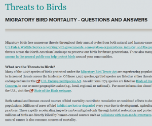
Threats to Birds – This page provides information on actions or measures that can be taken to benefit birds, including minimizing habitat impacts and human-made objects contributing to bird loss.
[/showhide]