The following are a list of resources and products external to AKN that may be useful or of interest to AKN users:
Rapid Avian Information Locator (RAIL) Tool
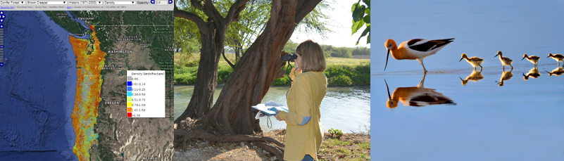
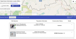 The RAIL Tool allows the user to query a specific geographic location and return a list of birds that are known to occur in that area based on the underlying data in the AKN, along with a wealth of information about those birds including their conservation status and population size at various scales. The tool imports information from the Partners in Flight (PIF) Avian Conservation Assessment Database (ACAD) and the PIF Population Estimates Database, and also incorporates other supplemental information (e.g. conservation status on multiple scales, clutch size, bird weight, size and diet, primary habitat, photos and range maps) that might be helpful for permitting and making conservation and management decisions for birds.
U.S. Fish & Wildlife Service’s Information for Planning and Consultation (IPaC) Tool
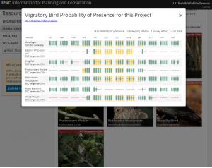
The IPaC Tool allows users to view their project or activity’s potential impacts on U.S. Fish & Wildlife Service’s Trust Resources, including endangered and threatened species and migratory bird species of concern. The Migratory Bird section of IPaC is generated using real-time data in the AKN, which has been shared at Data Sharing Level 2 or above. For a short web tutorial on this tool, please visit the IPaC Tool video tutorial.
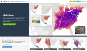
eBird Status and Trends provides an unparalleled window into the full annual cycle of bird populations in North America. Cornell Lab of Ornithology researchers have developed these novel statistical techniques to model eBird data across continents at fine spatiotemporal scales. Maps, charts and other products explore the range, abundance, habitat, and trends for 107 avian species.
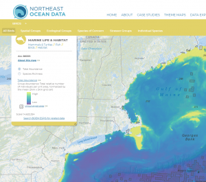
The Northeast Ocean Data Portal is a centralized, peer-reviewed source of data and interactive maps of the ocean ecosystem and ocean-related human activities in the northeastern United States. The maps on the Portal show the richness and diversity of the ecosystem and illustrate the many ways that humans and environmental resources interact. By providing user-friendly, centralized, and free access to data, information, and tools, the Portal facilitates decision making by a broad range of government agencies, industries, non-government organizations, academic entities, and individuals. Portal users can access data in a variety of ways: by theme, by making custom maps in the Data Explorer, or by directly downloading the data for personal use.
Mid-Atlantic Ocean Data Portal
The Mid-Atlantic Ocean Data Portal is an online toolkit and resource center that consolidates available data and enables state, federal and local users to visualize and analyze ocean resources and human use information such as fishing grounds, recreational areas, shipping lanes, habitat areas, and energy sites, among others.
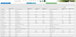
Partner’s in Flight Conservation Assessment Database
The PIF Conservation Assessement Database provides global and regional conservation assessments of each bird species that, among other uses, can be used to objectively assign regional and continental conservation priorities among birds. Currently, Bird Conservancy of the Rockies maintains PIF species assessment data on all bird species in the U.S. Canada, and Mexico.
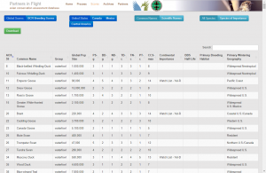
Partner’s in Flight Landbird Population Estimates Database
 The PIF Landbird Population Estimates Database aims to: (1) provide users access to the estimates of landbird populations published in the North American Landbird Conservation Plan (Rich et al. 2004), which were based mainly on Breeding Bird Survey data from the 1990s: (2) allow users to view and download estimates for landbird populations at a variety of geographic scales, and (3) provide transparent access to the methodologies, assumptions, data sources, and species-specific correction factors used by Partners in Flight to create these estimates.
MarineCadastre.gov was developed through a partnership between the U.S. Department of Commerce’s National Oceanic and Atmospheric Administration (NOAA) Office for Coastal Management and the U.S. Department of the Interior’s Bureau of Ocean Energy Management (BOEM). MarineCadastre.gov is an integrated marine information system that provides data, tools, and technical support for ocean and Great Lakes planning. MarineCadastre.gov was designed specifically to support renewable energy siting on the U.S. Outer Continental Shelf but also is being used for other ocean-related efforts. MarineCadastre.gov includes the Ocean Reports Tool, which is a web-based, report-centric tool for coastal and ocean planners. Powered by over 100 datasets, it provides summary statistics and infographics for six main topics: general information, energy and minerals, natural resources and conservation, oceanographic and biophysical, transportation and infrastructure, and economics and commerce.